1/10


Memory-Map
1K+下载次数
8MB大小
2.9.0(03-02-2021)最新版本

详情评价版本信息
1/10
Memory-Map介绍
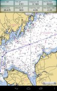
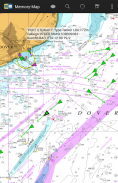
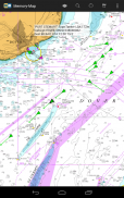
Memory-Map应用程序可将您的手机或平板电脑变为功能齐全的户外GPS或海图绘图仪,并允许您使用USGS Topo地图,NOAA海图以及其他专业地图进行导航,即使没有无线互联网信号。
地图即时下载,可以预先加载,以便脱机使用。将应用和地图加载到手机或平板电脑后,实时GPS导航不需要蜂窝网络覆盖或互联网连接。
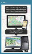
Memory-Map应用程序可以用作独立的GPS导航器,但它也可以与Windows PC或Mac应用程序(免费下载)结合使用,用于规划,打印和加载地图,航点和路线到手机/平板电脑。
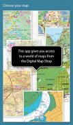
Memory-Map包括免费访问1:250,000比例尺的地形图和世界各地的许多其他免费地图。更详细的地图可供下载和购买,免费试用,购买前,限时演示选项。可用的地图包括军械测量,Hema,USGS四边形,NOAA,英国海军部和DeLorme。地图可以在您的PC以及手机和平板电脑上使用。 Cloud Sync功能允许您在所有设备上保持叠加数据的一致性。
功能包括:
访问各种全球地图和图表。
自动下载当前位置的免费地图
创建和编辑标记和路线。
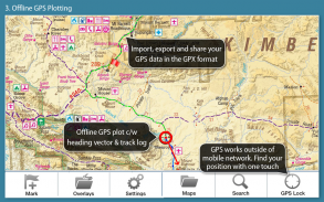
以开放式GPX格式导入和导出标记,路径和轨迹
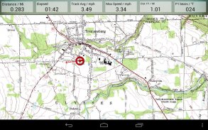
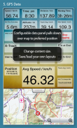
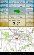
显示;位置,课程,速度,标题,海拔高度和平均值
位置坐标包括Lat / Long,UTM和GB Grid
“法规”,“航海”或“公制”中显示的单位
支持GPS和Compass传感器(如果有)。
地名索引,可以离线使用。
移动地图,锁定GPS位置并自动滚动地图
记录面包屑跟踪/跟踪日志。
将位置标记或跟踪日志共享为GPX文件
接近警报
全海洋仪表功能,具有AIS,DSC和锚定报警功能
NMEA数据接口通过WiFi或蓝牙
AIS碰撞警报,可调节A级和B级目标的阈值
在Android Wear手表上显示警报通知和导航数据
气压计和相对高度
Memory-Map - 版本2.9.0
(03-02-2021)新特性Tap a track to select/editFind time, speed and altitude at any point on a trackSplit/Join tracksSplit/Join routesAdded line styles (dash, dot, etc) for tracks and routesScoped Storage for Data Layout files and GPX data.Display maps storage by folderDelete all maps by type or folder

Memory-Map - APK信息
APK版本: 2.9.0程序包: com.memorymap.mm2名称: Memory-Map大小: 8 MB下载次数: 396版本: 2.9.0发布日期: 2024-05-21 06:36:05最小屏幕: SMALL支持的CPU:
程序包ID: com.memorymap.mm2SHA1签名: 8D:BC:9D:5D:2A:DA:98:23:47:AA:15:42:65:12:B2:2C:3F:90:AD:91开发商 (CN): Richard Stephens组织 (O): "Memory-Map本地 (L): Trumansburg国家/地区 (C): US州/市 (ST): NY程序包ID: com.memorymap.mm2SHA1签名: 8D:BC:9D:5D:2A:DA:98:23:47:AA:15:42:65:12:B2:2C:3F:90:AD:91开发商 (CN): Richard Stephens组织 (O): "Memory-Map本地 (L): Trumansburg国家/地区 (C): US州/市 (ST): NY
Memory-Map的最新版本
2.9.0
3/2/2021396 下载次数5 MB 大小
其他版本
2.8.2
19/9/2020396 下载次数5 MB 大小
2.5.4
2/1/2018396 下载次数9 MB 大小
2.4.1
9/8/2016396 下载次数7 MB 大小
2.1.5
16/7/2014396 下载次数2.5 MB 大小


同类应用


English


